
India–U.S. NISAR Satellite Successfully Launched – Why It Matters for Exams & Our Planet
If you’re preparing for SSC, UPSC, or banking exams, here’s a news update that might just show up in your next GK section. Let’s simplify it smartly — because this mission isn’t just about reaching space, it’s about understanding our planet and its people.
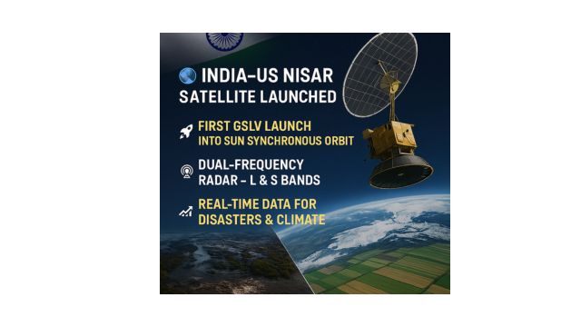
Key Highlights of the News: What Happened & Why It’s Big
- On July 30, 2025, ISRO successfully deployed the NISAR satellite (NASA–ISRO Synthetic Aperture Radar) into orbit using the GSLV-F16 rocket from the Satish Dhawan Space Centre in Sriharikota.
- The GSLV rocket successfully inserted the satellite into a Sun-Synchronous Polar Orbit (SSPO) at an altitude of 743 km — a milestone as it was the first-ever SSPO mission accomplished by a GSLV.
- Weighing 2,392 kg, NISAR is the world’s most advanced Earth observation satellite, jointly developed by NASA and ISRO.
- It uses dual-frequency SAR radar (L-band from NASA and S-band from ISRO) to observe Earth’s land, ice, sea, and vegetation — day and night, in any weather.
- This mission became the first collaborative Earth science venture between India and the U.S., establishing a new milestone in global space partnership.
🎯 Mission Purpose: To monitor natural disasters, climate change, crop output, glacier changes, deforestation, soil moisture, and more — all in real time.
Why This News Matters for Exams
This mission isn’t just a space event – it’s deeply tied to environment, disaster management, climate change, science & tech, and international relations – all core parts of General Studies.
Potential MCQs for Exams:
- What is the full form of NISAR?
a) National Indian Space Advanced Radar
b) NASA–ISRO Synthetic Aperture Radar ✅
c) National ISRO Space Aviation Radar
d) None of the above - Which Indian rocket carried the NISAR satellite?
a) PSLV-C61
b) GSLV Mk III
c) GSLV-F16 ✅
d) SSLV - NISAR was launched into which orbit?
a) Geo-stationary
b) Medium Earth Orbit
c) Sun Synchronous Polar Orbit ✅
d) Equatorial Orbit
Topics You Can Connect in Preparation:
- Synthetic Aperture Radar (SAR) – a powerful tool used in remote sensing to capture detailed surface images regardless of weather or lighting conditions.
- Sun Synchronous Orbit – why it’s used for Earth observation
- ISRO’s international collaborations
- Climate change & environmental monitoring
- Disaster risk reduction & sustainable development
Official Confirmations & Govt Statements
- ISRO Chairman Dr. V. Narayanan confirmed the successful deployment of the satellite and its precise injection into orbit.
- NASA officials, including Casey Swails (Deputy Associate Administrator), emphasized how the mission will assist global decision-makers in responding faster to natural calamities.
- Union Minister Jitendra Singh celebrated the launch as a significant step forward in India-U.S. space partnership and shared the news on X (previously known as Twitter).
- This mission was a direct result of the Feb 2025 bilateral summit between Prime Minister Narendra Modi and former U.S. President Donald Trump, highlighting the year as a landmark in civil space cooperation.
How NISAR Will Help Us All – Not Just Scientists
NISAR isn’t just floating around in space; it’s working for us 24/7. Here’s how:
✅ 1. Early Disaster Detection
From earthquakes to landslides, floods, and glacier melting, NISAR will detect small changes in Earth’s surface, helping disaster teams act faster and smarter.
✅ 2. Climate Change Monitoring
With real-time data on ice sheet movements, soil moisture, wetlands, and deforestation, NISAR will give us insights into global warming’s true pace.
✅ 3. Agriculture & Food Security
NISAR’s high-resolution imaging can map farmland, track crop patterns, and assess biomass – helping increase productivity and plan better for food supply.
✅ 4. Infrastructure Monitoring
Whether it’s tracking dams, bridges, or urban growth, the satellite’s data will allow governments to manage critical infrastructure more safely.
Trivia & Lesser-Known Facts
Here are some cool facts you may not know – great for interviews or group discussions!
- 🛰️ First Use of SweepSAR Technology: NISAR will use SweepSAR – a revolutionary tech that gives wide coverage (242 km swath) and fine detail.
- 📡 World’s Largest Radar Antenna in Space: A 12-meter unfurlable mesh antenna, created by NASA, is now orbiting Earth on an Indian satellite bus.
- 🇮🇳🇺🇸 $1.5 Billion Joint Investment: It’s among the costliest Earth science missions ever, emphasizing the value both countries place on climate science.
Mission Phases: From Launch to Science Mode
The journey of NISAR is broken into phases:
- Launch Phase (✔️ Completed) – GSLV-F16 carried NISAR to space.
- Deployment Phase – A complex 9-meter boom unfolds the massive radar antenna 10 days post-launch.
- Commissioning Phase (First 90 days) – Engineers check instruments, calibrate radar, and prepare for science ops.
- Science Operations Phase (Next 5 Years) – Real-time data collection, monitoring, and Earth analysis begins.
ISRO & NASA – A True Team Effort
This project is a perfect blend of India’s space engineering and America’s radar technology:
| Component | Developed By |
| Satellite Bus, S-band SAR, Solar Array | ISRO |
| Equipped with an L-band Synthetic Aperture Radar, a 12-meter deployable antenna, and an advanced boom structure. | developed by NASA’s Jet Propulsion Laboratory. |
| Launch Vehicle (GSLV-F16) | ISRO |
| Orbit Maneuver & Radar Planning | NASA |
| Ground Support & Data Processing | Both ISRO & NASA |
Impact on India’s Space Reputation
After facing two back-to-back failures (PSLV-C61 in May and GSLV’s earlier NVS-02 mission), this success has reaffirmed ISRO’s position as a reliable global space player.
Moreover, ISRO’s experience in Earth observation (like Resourcesat & RISAT) is now amplified with NASA’s cutting-edge radar systems, opening new opportunities for climate tech, space diplomacy, and environmental science.
Final Takeaway for Aspirants
- Remember: NISAR = India–U.S. + Earth Observation + SAR Radar + Disaster Management + Climate Monitoring.
- For exams, focus on acronym meanings, technical features, and mission purpose.
- Motivational Note: “Stay consistent with your preparation – the future belongs to those who keep watching the Earth and learning from it!”
Quick Quiz Time – Test Your Prep!
Q1. What is the launch vehicle that carried the NISAR satellite?
a) PSLV-C61
b) GSLV-F16 ✅
c) GSLV Mk III
d) SSLV
Q2. NISAR is the first Earth observation satellite using:
a) Single-band radar
b) Dual-frequency SAR ✅
c) Optical sensors
d) Lidar tech only
Q3. Which orbit is NISAR placed in?
a) Geo-synchronous
b) Sun-Synchronous ✅
c) Elliptical
d) Equatorial
Q4. What is the expected mission life of NISAR?
a) 2 years
b) 3 years
c) 5 years ✅
d) 10 years
✅ That’s all you need to know for today’s current affairs! Stay updated, stay confident, and don’t forget to check out our free MCQ quiz below to test your prep. All the best!
India has taken a major step in strengthening its short-range air defense with the successful test of DRDO’s 4th Generation VSHORADS missile system, which promises enhanced protection against aerial threats like drones, helicopters, and low-flying aircraft.